Winter Navigation with a Map and Compass
Date and Time
Saturday Feb 22, 2025
10:00 AM - 4:00 PM PST
Saturday, February 22nd
10am-4pm
Location
Tahoe Rim Trail Association Office
128 Market Street
Suite E3
Stateline, NV 89449
Fees/Admission
$110
Register
Description
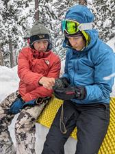
Join the Tahoe Rim Trail Association for a day in the classroom and field to learn basic map and compass skills in the winter. This course will teach you one of the most basic and essential outdoor skills- navigation without relying on a battery. Students can expect a morning in the classroom and then hitting the outdoors for hands-on practice. Objectives include map nomenclature and meaning of contour lines, compass basics, and orienteering to find one’s position with field practice.
Knowing how to use a map and compass will greatly reduce your chances of getting lost, especially in the winter when you can’t see the trail. Maps have stood the test of time and are still pertinent today. The Babylonians created and used one of the oldest surviving maps to this day, and the Chinese Han Dynasty used magnetic compasses as early as 206 BC. The birth of the smartphone and personal global positioning systems (GPS) have not outdated the centuries-old navigation skill by map and compass. The earth’s magnetic field will never run out of battery.